Drone Surveying on the Sunshine Coast & Surrounds
We support civil and commercial projects with accurate survey data, experienced surveyors and clear communication.
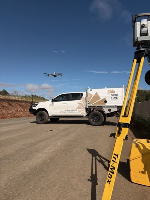
Advanced Drone Surveying Across the Sunshine Coast
Drone surveying provides an efficient way to capture detailed site information where traditional methods may be slower or more disruptive. At Next Step Surveying, we use drone surveying across the Sunshine Coast to support projects that require accurate data with minimal impact on site activity. Based in Caloundra and servicing South East Queensland, our team uses UAV technology to deliver reliable data that supports planning and project decisions.
We focus on outcomes that matter on site, such as:
- Fast capture of data across large or complex areas
- Improved safety by reducing the need for extended site access
By combining aerial data with our broader surveying experience, we ensure results are practical and ready to use. Our team works with project partners to deliver information that integrates smoothly with existing survey data and design models. Get in touch to see how our drone surveying services can support your project by calling 0494 186 100.
Aerial Data You Can Build On
Our UAV and scanning services provide detailed spatial information that supports a wide range of project needs. Using unmanned aerial vehicles, we capture high-definition imagery and accurate ground data across large areas efficiently and cost-effectively. This dataset supports conventional surveying methods and is well suited to large-scale pre-design surveys and construction projects where tracking earthworks and capturing reliable surface data is critical.
Our laser scanning services use advanced technology to capture high-density point clouds that can be exported in formats compatible with industry software. This supports structural steel design, concrete and structural analysis, pre-design surveys and projects where access is restricted or safety risks limit traditional survey methods. By delivering accurate, detailed spatial data, we help teams make informed decisions at every stage.
Whether supporting early planning or ongoing site assessment, our UAV and scanning services are delivered with accuracy and clarity in mind. Explore our services to learn more or get in touch to discuss how this technology can support your project.
Advanced Technology
Efficient Workflows
Accurate Outputs
Get in Touch
Need aerial site data without disrupting your project?
Get in touch with our team and we’ll help you take the next step with confidence.
Contact Us
Thank you for contacting Next Step Surveying.
We will get back to you as soon as possible.
Oops, there was an error sending your message.
Please try again later.
FAQ
When is drone surveying more suitable than ground-based surveying?
Drone surveying is particularly useful for large, complex or hard-to-access sites. It allows data to be captured efficiently without placing surveyors in difficult or unsafe areas. This approach can reduce time on site while still providing detailed spatial information. It is often used alongside traditional methods rather than replacing them entirely.
How accurate is data captured through UAV and scanning methods?
Accuracy depends on factors such as flight planning, ground control and data processing. When correctly managed, UAV and scanning data can achieve high levels of precision suitable for planning, analysis and design support. The data is typically validated against established control to ensure reliability. Understanding the intended use of the data helps determine the required accuracy.
What types of projects benefit most from UAV and scanning?
UAV and scanning are commonly used on infrastructure, civil and large development sites. They are useful for capturing terrain, monitoring progress and assessing existing conditions. Projects with time constraints or complex site conditions often benefit most. The technology supports better visibility across the site as it changes over time.